

The Chandratal Lake which is at the core of the sanctuary is a high altitude lake located at about 4300 meters above sea level. The lake has been formed due to blockades of the rock basin by scree and moraine deposits. Glaciers are the main source of inflow into the lake. Chandratal lake is a high-altitude wetland and is identified on the List of Wetlands of International Importance as defined by the Ramsar Convention, for the conservation and sustainable use of wetlands recognizing the fundamental ecological functions of wetlands and their economic, cultural, scientific, and recreational value. The Sanctuary is almost contiguous with the Upper Spiti Landscape, which is the first landscape identified for conservation under Project Snow Leopard. The Sanctuary is crucial part of Central Asian flyway for migratory birds.

Tourism is one of the most important aspects of the Chandratal Wildlife Sanctuary. The area around Chandratal is scenic and is extremely popular as a tourist destination. Over subsequent years, there has been a steady rise in the number of tourists visiting Chandratal . In addition to rising tourist footfall, parts around the Chandratal Wildlife Sanctuary are accessed by migratory herders who hold rights to graze their sheep and goat in these areas, in summer months.

Fauna @ Chandratal Wildlife Sanctuary
The mammalian diversity of the region is not exceptionally large, but several species restricted to Trans-Himalayas occur here. The mammals recorded at Chandra Tal include the Snow leopard (Panthera uncia), Himalayan Ibex (Capra Siberia himalayanus), Stone Marten(Martes foina), Mountain weasel (Mustela altaica), Tibetan Wolf (Canis lupus chance), Red Fox (Vulpes vulpes), Royle’s Pika (Ochotona roylei), Woolly Hare (Lepus oiostolus) and Himalayan Marmot (Marmota himalayana). The avifauna of the area currently stands at 27 species belonging to 15 families. A single species, Curlew Sandpiper (Calidris ferruginea) is classified as Near Threatened (NT) while the rest 26 species are classified as Least Concern (LC) by IUCN.
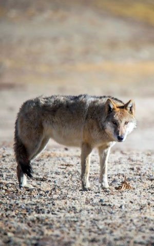
Himalayan Wolf
Himalayan Wolf
The Himalayan Wolf, scientifically known as Canis lupus chanco, is an enigmatic and elusive creature that roams the rugged landscapes of the Himalayas. This unique subspecies of the gray wolf is perfectly adapted to the harsh and unforgiving environment of the high-altitude regions, where it navigates through steep mountain slopes and dense forests with remarkable agility. With its thick fur coat, the Himalayan Wolf withstands the extreme cold temperatures prevalent in its habitat, blending seamlessly into the snowy terrain.
Despite its majestic presence, the Himalayan Wolf remains one of the least studied and understood canid species in the world. Its elusive nature and remote habitat make it a challenging subject for scientific research and conservation efforts. However, local communities living in the Himalayan region often share stories and legends about this mysterious creature, depicting it as a symbol of wilderness and resilience. As human activities continue to encroach upon its habitat, efforts to protect and conserve the Himalayan Wolf are crucial to ensuring the ecological balance of the fragile Himalayan ecosystem.

Red Fox
Red Fox
The Red Fox, scientifically known as Vulpes vulpes, is a cunning and adaptable mammal found across diverse habitats in the Northern Hemisphere, including North America, Europe, Asia, and parts of North Africa. With its striking reddish-orange fur coat and bushy tail, the Red Fox is one of the most recognizable and widespread members of the canid family.
Renowned for its intelligence and resourcefulness, the Red Fox has successfully adapted to a wide range of environments, from forests and grasslands to urban areas and agricultural landscapes. Its diet is incredibly diverse, consisting of small mammals, birds, insects, fruits, and even scavenged human food. With keen senses of sight, smell, and hearing, the Red Fox is a skilled hunter and opportunist, capable of exploiting various food sources to survive.
Beyond its ecological significance, the Red Fox holds a prominent place in folklore and mythology around the world, often depicted as a symbol of cunning and trickery. Despite facing threats such as habitat loss, persecution, and diseases like rabies, the Red Fox continues to thrive in many regions, showcasing its remarkable ability to adapt and endure in ever-changing environments. Efforts to conserve this iconic species are crucial not only for maintaining biodiversity but also for preserving the cultural and ecological heritage associated with the Red Fox’s presence in our natural world.
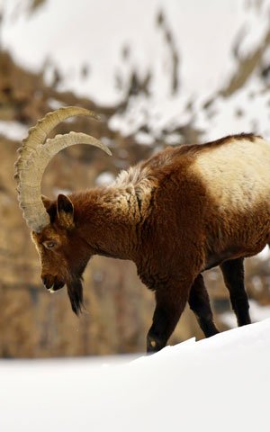
Himalayan Ibex
Himalayan Ibex
The Siberian Ibex, scientifically known as Capra sibirica, is an emblematic wild goat species native to the rugged and remote mountains of Central Asia, including the Altai, Tien Shan, and Himalayan ranges. Renowned for its majestic appearance and impressive curved horns, the Siberian Ibex roams the steep cliffs and rocky slopes of its habitat with remarkable agility and grace.
With its thick fur coat and sturdy build, the Siberian Ibex is well-adapted to the harsh and unforgiving environments of high altitudes, enduring freezing temperatures and sparse vegetation. Its diet consists mainly of grasses, herbs, and shrubs found in alpine meadows, which it forages for year-round.
As a keystone species, the Siberian Ibex plays a crucial role in shaping its ecosystem by controlling vegetation growth through grazing and providing prey for predators such as snow leopards and wolves. However, like many species inhabiting mountainous regions, the Siberian Ibex faces threats from habitat loss, poaching, and competition with domestic livestock.
Conservation efforts aimed at protecting its habitat, reducing illegal hunting, and promoting sustainable land management practices are essential for ensuring the long-term survival of this iconic species and preserving the ecological integrity of the high-altitude ecosystems it inhabits. Through collaborative conservation initiatives and increased awareness, we can secure a future where the Siberian Ibex continues to thrive in its natural environment.

Snow Leopard
Snow Leopard
The Snow Leopard, scientifically known as Panthera uncia, is a mesmerizing big cat inhabiting the rugged and remote mountain ranges of Central and South Asia. Renowned for its elusive nature and captivating beauty, the Snow Leopard’s thick fur coat, patterned with exquisite rosettes, enables it to blend seamlessly into its rocky alpine habitat, making it a master of stealth and camouflage.
As a apex predator, the Snow Leopard plays a crucial role in maintaining the delicate balance of its ecosystem by regulating prey populations, such as wild sheep and ibex. With its remarkable agility and powerful physique, this solitary and nocturnal hunter traverses steep cliffs and icy slopes with ease, seeking out prey under the cover of darkness.
Despite its iconic status, the Snow Leopard faces numerous threats, including habitat loss, poaching, retaliatory killings by herders, and climate change-induced shifts in prey distribution. Conservation efforts focused on habitat protection, community-based conservation initiatives, and reducing human-wildlife conflicts are crucial for ensuring the survival of this magnificent feline species and preserving the biodiversity of the high-altitude landscapes it calls home.

Chukar Partridge
Chukar Partridge
The Chukar Partridge, scientifically known as Alectoris chukar, is a resilient and adaptable bird species native to the rocky slopes and arid regions of Eurasia and the Middle East. With its distinctive markings, including barred flanks and a chestnut-colored back, the Chukar Partridge is easily recognizable. Renowned for its strong flight and agile movements, it thrives in diverse habitats, from steep mountain ranges to scrublands and desert valleys.
As a popular game bird, the Chukar Partridge holds cultural significance in many regions and is sought after by hunters for its flavorful meat and challenging hunting experience. Despite facing threats such as habitat loss, predation, and hunting pressure, this tenacious bird has shown resilience and adaptability in the face of changing environments. Conservation efforts aimed at protecting its natural habitat, controlling hunting activities, and promoting sustainable land management practices are essential for ensuring the long-term survival of the Chukar Partridge and preserving its role in the ecosystems it inhabits.

Golden Eagle
Golden Eagle
The Golden Eagle, scientifically known as Aquila chrysaetos, is a majestic raptor renowned for its impressive size, strength, and aerial prowess. With a wingspan reaching up to 7 feet, this iconic bird of prey commands the skies across the Northern Hemisphere, inhabiting diverse landscapes ranging from open plains and mountains to forests and coastal cliffs. Its striking plumage, featuring dark brown feathers with golden highlights on the nape and crown, lends it an aura of regal beauty.
As an apex predator, the Golden Eagle plays a vital role in maintaining ecological balance by controlling populations of small mammals and birds. With keen eyesight and powerful talons, it hunts a wide range of prey, including rabbits, hares, ground squirrels, and even other birds. Revered in many cultures as a symbol of strength, freedom, and nobility, the Golden Eagle holds a special place in human history and mythology, often depicted as a majestic guardian of the wilderness.
Despite facing threats such as habitat loss, persecution, and collisions with man-made structures, conservation efforts focused on habitat protection, reducing human disturbance, and mitigating human-wildlife conflicts are essential for ensuring the continued survival of this magnificent bird. Through collaborative conservation initiatives and increased awareness, we can secure a future where the Golden Eagle continues to soar high and inspire awe in the hearts of all who behold it.

Himalayan Griffon
Himalayan Griffon
The Himalayan Griffon, scientifically known as Gyps himalayensis, is a magnificent and vital scavenger inhabiting the rugged landscapes of the Himalayas and surrounding regions. With a wingspan that can exceed 3 meters, this impressive bird of prey is one of the largest vulture species in the world. Its striking appearance, featuring a bald head and neck, contrasts sharply with its dark plumage, while its powerful beak and keen eyesight make it an efficient scavenger.
As a key component of the mountain ecosystem, the Himalayan Vulture plays a crucial role in cleaning up carcasses and preventing the spread of disease. By efficiently disposing of animal remains, it helps maintain the health and balance of the environment. However, like many vulture species worldwide, the Himalayan Vulture faces significant threats, including habitat loss, poisoning from ingesting contaminated carcasses, and collisions with power lines and wind turbines.
Conservation efforts aimed at protecting vulture habitat, reducing human-wildlife conflicts, and implementing measures to prevent poisoning are essential for safeguarding the Himalayan Vulture and ensuring its continued presence in the region. Through collaborative conservation initiatives and public awareness campaigns, we can work towards a future where these magnificent birds thrive in their natural environment, contributing to the ecological health of the Himalayan ecosystem.

Himalayan Snowcock
Himalayan Snowcock
The Himalayan Snowcock, scientifically known as Tetraogallus himalayensis, is a striking bird species endemic to the high-altitude regions of the Himalayas and adjoining mountain ranges. With its robust build, mottled gray-brown plumage, and distinctive white patches on its wings, this elusive bird is perfectly adapted to the rugged and inhospitable terrain of its habitat. The Himalayan Snowcock is renowned for its haunting calls echoing across the alpine slopes, adding to its mystique and allure.
Thriving in alpine meadows and rocky slopes above the tree line, the Himalayan Snowcock is a master of survival in harsh environments. Its diet primarily consists of grasses, seeds, and alpine vegetation, which it forages for among the rocks and scree slopes. Despite its remarkable adaptations, the Himalayan Snowcock faces threats from habitat degradation, climate change, and disturbance from human activities such as trekking and tourism.
Efforts to conserve the Himalayan Snowcock focus on protecting its alpine habitat, minimizing human disturbance, and conducting research to better understand its ecological needs and population dynamics. By raising awareness about the importance of preserving the unique biodiversity of high-altitude ecosystems, we can ensure the survival of the Himalayan Snowcock and other iconic species that call the Himalayas home.

Rosefinch
Rosefinch
The Rosefinch, belonging to the genus Carpodacus, encompasses a diverse group of small to medium-sized passerine birds known for their vibrant plumage and melodious songs. With a distribution spanning across Europe, Asia, and North America, these charming birds inhabit a variety of habitats ranging from mountain forests and scrublands to alpine meadows and tundra.
One of the most distinctive features of the Rosefinch is its colorful plumage, characterized by shades of red, pink, or orange, often accentuated by contrasting patterns and markings. These striking colors serve not only to attract mates but also to blend into their natural surroundings, offering camouflage from potential predators.
Throughout the breeding season, male Rosefinches can be heard singing from prominent perches, their melodious tunes filling the air as they establish territories and court potential mates. Meanwhile, females diligently construct nests hidden amidst dense vegetation, where they lay and incubate their eggs.
Despite their widespread distribution, Rosefinches face various threats, including habitat loss, climate change, and predation by introduced species. Conservation efforts aimed at protecting their habitats, preserving nesting sites, and mitigating the impacts of human activities are essential for ensuring the continued survival of these delightful birds and preserving their beauty for generations to come.

Mountain Weasel
Mountain Weasel
The Mountain Weasel, belonging to the genus Mustela, is a small and agile carnivorous mammal known for its slender body, short legs, and long, flexible torso. Found in various habitats across Europe, Asia, and North America, these cunning hunters play a crucial role in controlling rodent populations and maintaining ecological balance.
With their keen senses of smell, sight, and hearing, Weasels are skilled predators, preying on a variety of small mammals such as mice, voles, and rabbits. Their long, slender bodies allow them to pursue their prey into tight spaces and burrows, making them efficient hunters.
Despite their small size, Weasels are tenacious and fearless, known for their ability to take down prey much larger than themselves. They are also highly territorial animals, fiercely defending their hunting grounds from intruders.
While Weasels are adaptable and resilient creatures, they face threats from habitat loss, pollution, and predation by larger predators. Conservation efforts aimed at protecting their natural habitats and ensuring the availability of prey species are essential for safeguarding the survival of these fascinating mammals and maintaining the health of ecosystems they inhabit.
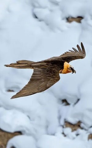
Lammergeier
Lammergeier
The Lammergeier, also known as the Bearded Vulture or ossifrage, is a remarkable bird of prey that inhabits high mountain ranges across Europe, Asia, and Africa. With a wingspan of up to 2.8 meters and distinctive feathered tufts resembling a beard, the Lammergeier is a majestic and awe-inspiring sight soaring above alpine landscapes.
One of the Lammergeier’s most fascinating traits is its unique feeding behavior. Unlike other vultures that primarily scavenge carcasses, the Lammergeier is primarily a bone-eater, specializing in consuming bones. It accomplishes this by dropping bones from high altitudes onto rocky surfaces, where they shatter into smaller pieces, allowing the Lammergeier to access the nutritious marrow inside.
Despite its formidable appearance, the Lammergeier is a relatively gentle bird, preferring solitude and rarely engaging in direct confrontation with other species. It nests on remote cliffsides, where it lays a single egg and raises its young in the harsh alpine environment.
While the Lammergeier faces threats such as habitat loss, disturbance at nesting sites, and poisoning from ingesting lead fragments in carcasses, conservation efforts focused on habitat protection, reducing human disturbance, and raising awareness about the importance of these magnificent birds are crucial for ensuring their continued survival in the wild.
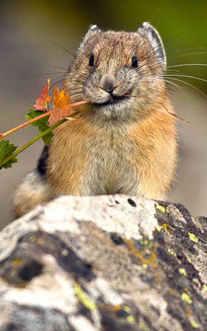
Pika
Pika
The Pika, a small mammal belonging to the Ochotonidae family, inhabits rocky mountainous regions across Asia and North America. Despite its diminutive size, the Pika plays a vital role in alpine ecosystems as a prey species for various predators and as a key contributor to nutrient cycling.
Known for its round body, short limbs, and distinctive rounded ears, the Pika is well-adapted to its high-altitude habitat. It constructs elaborate burrow systems among rocky outcrops, providing shelter from predators and harsh weather conditions. During the brief alpine summer, the Pika diligently gathers vegetation, which it dries and stores in its burrows to sustain itself through the long winter months.
As a keystone species, the Pika is an indicator of environmental health in alpine ecosystems. However, it faces challenges due to habitat loss, climate change, and competition with livestock for resources. Conservation efforts aimed at preserving alpine habitats, mitigating climate change impacts, and managing grazing practices are essential for ensuring the survival of this charismatic and ecologically important species.
-
 Climate
 -
Geology, terrain, rocks and soil
-
Management
-
Eco Sensitive Zone for Chandratal WLS
Climate
Chandra Tal occurs on the leeward side of the Pir Panjal branch of the Himalaya that cut off the monsoonal effect from the plains rendering the area dry and cold. Westerly disturbances in winter bring some precipitation in the form of snow, but most areas still receive much lower snowfall compared to the adjacent Lahaul Valley, Kullu and Kinnaur regions. The annual precipitation in Kaza is recorded at c. 200mm annually. The temperature ranges from -40 degree Celsius in winter to c.30 degree Celsius in peak summer, with the minimum temperature remaining sub-zero from September to April in most places. Severe winds occur almost every day and are further reason for the desiccated atmosphere and lack of trees. The overall climate is thus dry and cold with long winter descending from mid-November to March. The ice begins to melt in April heralding the spring with sprouting at lower, south facing slopes that extend to the higher elevations by late May when the peak plant growth season of summer begins. Senescence sets in by late summer leading to the short autumn season.
Geology, terrain, rocks and soil
The Geomorphological set up of the area is highly complex. The terrain has an topography and is traversed by deep valleys and high hill ranges. The terrain can be divided into two major geomorphological units viz. Structural hills and Valley fills. Structural hills are caused by rocks belonging to Pre-Cambrian, Palaeozoic, Mesozoic and Cainozoic eras. The rocks are generally trending in NNE-SSW and NE-SW direction with steep slopes. Valley fills include both fluviatile deposits and moraines. These deposits occur as narrow and elongated strips along the main streams. Glacial deposits are under the influence of running water and have been termed as glacio-fluviatile deposits. Fluviatile terrain is demarcated in the lower reaches of both the Chenab and Spiti river while glacio-fluviatile deposits are confined to the upper reaches of drainage systems. Most of the area in Spiti may be called alpine meadow as the upper stratum of earth and vegetable mould is filled with incompletely decomposed roots of grass and other small plants. Due to glacial and fluvial movements the soil from the upper slopes has been carried down to the lower slopes where the depth of the soil is deeper. The nature of the soil varies little and it may be described as a light sandy loam.
Management
The Chandratal Wildlife Sanctuary is managed by the office of the Divisional Forest Officer (Spiti). A challenge with the management of Chandratal Wildlife Sanctuary is that it is isolated, with no connectivity- both road and communication-for most part of the year. While that secures it through winter when the area remains cut-off, it presents a challenge in summer when there is a need to regulate the use of the area. Management is being carried out as per Management Plan approved for the period 2018-2028.
Eco Sensitive Zone for Chandratal WLS
Draft notification of eco sensitive zone around Chandratal wildlife sanctuary was declared vide MINISTRY OF ENVIRONMENT, FOREST AND CLIMATE CHANGE NOTIFICATION S.O.1978(E). dated 3rd June, 2016 in exercise of the powers conferred by sub-section (1), read with clause (v) and clause (xiv) of sub-section (2) and sub- section (3) of section 3 of the Environment (Protection) Act, 1986 (29 of 1986) published, as required under sub-rule (3) of rule 5 of the Environment (Protection) Rules, 1986, for the information of the public likely to be affected thereby. The final notification of ESZ is under process.

Alpigene bluegrass (Poa alpigena)

Himalayan bistort, fleece flower, or knotweed (Bistorta affinis)
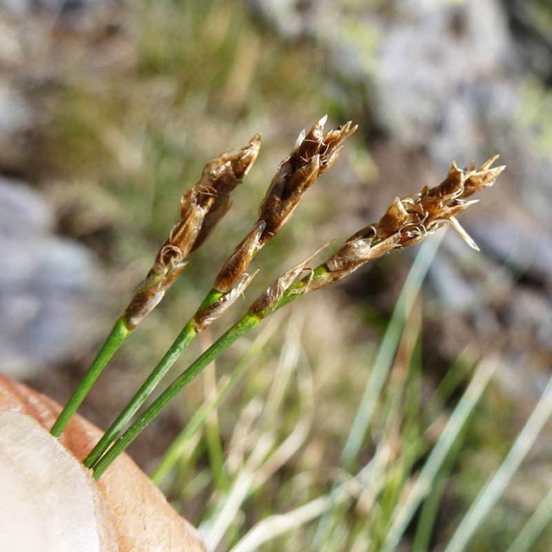
Kobresia (Kobresia royleana)

Narrow Leaf Hygrophila (Hygrophila lancea)

Plantains or fleaworts (Plantago depressa)
Flora @ Chandratal Wildlife Sanctuary
The vegetation of Chandra Tal is classified as ‘alpine scrub’(Champion and Seth, 1968) or ‘dry alpine steppe’ vegetation (Schweinfurt 1957, Puri et al. 1989). Such areas are typified by scattered and open bush-land mainly with herbaceous and shrub species. Plant growth is restricted to a short season (May-August) due to low temperatures during the rest of the year, and available soil moisture is an important limiting factor for plant growth during the growing season. Inter-annual variation in primary production is high and depends upon precipitation and temperature variations. Plants recorded from Chandra Tal WLS include grasses such as Polygonum, Stipa and Leymus, sedges like Cares, herbs such as Potentilla, Leontopodium and Geranium. Bistorta is a type of knotweed found in the sanctuary.